
Appalachian Trail
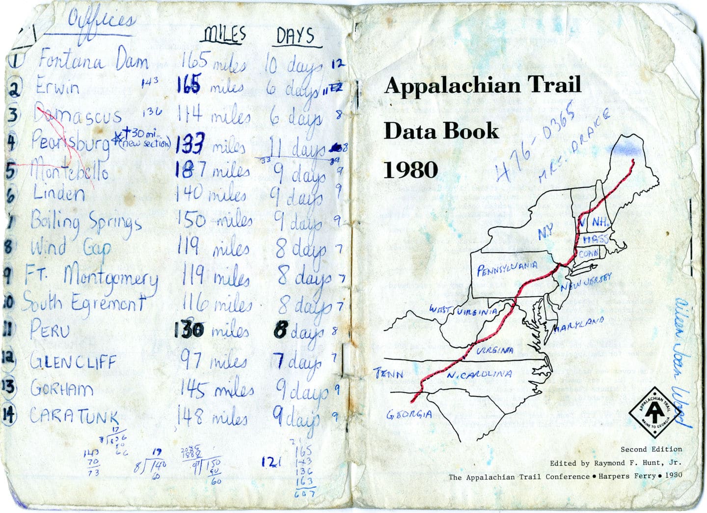
In 1981 we completed our first long distance journey together. We spent four and a half months backpacking the 2100 mile Appalachain trail through 14 states from Georgia to Maine.


Tracking Our Progress
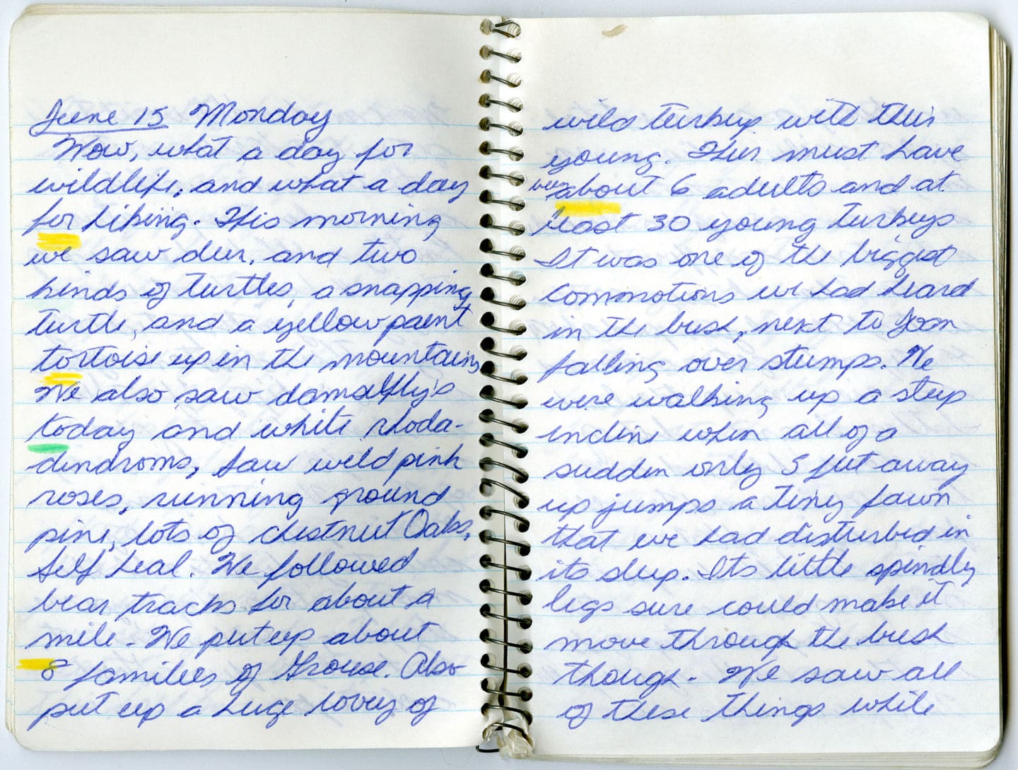
Wildlife Corridor through the Appalachians
Describing the wildlife we experienced on the trail.
The Waterfall Incident
Heavy packs, slippery rocks and waterfall crossings.

Rocks and a Scary Surprise
Five of the many snakes we encountered in the Appalachian were of the poisonous variety.
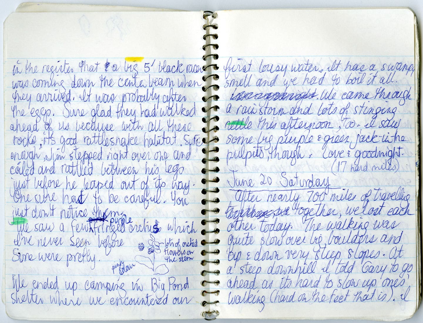
A Fork in the Trail
We lost each other in the mountains.


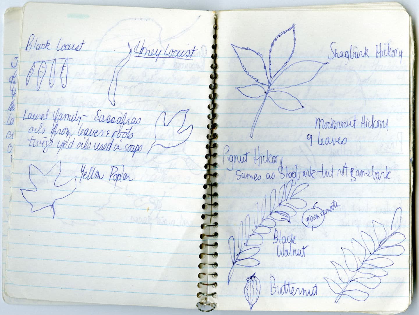
Nature Sketches
Frequently Asked Questions About The Appalachian Trail
Q How long does it take to hike the entire trail in one season?
A We took 4.5 months but the average is 6 months.
Q What kind of food can you pack for a hiking trip?
A . Jerky, rice, noodles, dried veggies, soup packets, dried fruit, bars, tea bags. It goes without saying that you are carrying everything on your back so weight and space are at a premium. Go with dried foods wherever possible. One-pot meals, quick snacks in your pocket are ideal. Reduce packaging. The AT recommends 1.5 – 2 lbs of high calorie food per day. We were hungry all the time for the first few weeks.
Q How do I re-supply along the way?
A We pre-packaged some supplies like dried foods and film, marked the boxes “Hold For A.T. Thru Hikers“, and mailed them out to 14 post offices en route before we began the trail. Amazingly, these small post offices found room to store all the through-hiker packages, and retrieving them became a weekly ritual which we very much enjoyed. When hot summer set in, we used the post office to send warm clothing and even our sleeping bags north to a post office in New Hampshire.
Most of our food was purchased at the little stores along the way which appreciated the business
Q Where do I find information and maps about the Appalachian Trail?
A The Appalachian Trail Conservancy www.appalachiantrail.org is the best place to start.
Q Do you need any permits or memberships to hike the trail?
A Where the AT passes through state and national parks, fees or permits may be required. Although we travelled independently camping in our tent the entire trip, you may need to make reservations at certain shelters and campsites.
Q How do you follow the Trail?
A The AT is marked with white blazes painted on everything from rocks to fence posts to trees. They are marked for people coming in either direction. Changes in direction are marked with a double blaze. Above treeline, or in areas where there are none of the above, rock cairns mark the way.
Q What are 4 important things that you carried all the way?
A flashlight, a stove, a small lightweight tent with good fly, a windbag turned water bag.
Q What did you wear on your feet?
A We hiked most of the trail in running shoes finding that hiking boots were too heavy. However the most important thing is that the footwear is comfortable and well broken in before going on a long hike.
Q What did you wear?
A Mostly shorts, T-shirt and wool socks but in colder weather we wore one piece overalls, a fleece jacket and rain jacket!
Q What happens if you get injured or sick along the trail? How did you communicate?
A Although many thru-hikers, by necessity, travel alone, we were fortunate to have each other for companionship and the added bonus of safety. Carry a map and know where you are in relation to the communities, the roads and the trail shelters. Today hikers probably all carry cell phones but we hiked the trail before they were even invented so our only communication with home was getting to a payphone.
Q What wildlife are you likely to encounter on the Trail?
A The Appalachian Trail is a wilderness corridor running through the highly populated eastern United States, and is therefore a refuge for many different creatures. Wildlife viewing is an incredible part of the trail experience. for birdlife, there are the huge turkeys, tiny warblers, young grouse learning to fly. There are black bears, white-tail deer, wild boars and moose depending what state you are walking through. The Eastern Appalachians are home to a number of species of snakes; some poisonous like the rattlesnake, cottonmouth and copperhead. However they are reclusive and sightings are more rare than common. Know where they are and what to avoid, and the snakes are the least of your concerns.
A memorable lunch in the Great Smokies took place just outside a shelter. We were making soup when a black bear wandered around. To avoid conflict, we backed into the shelter, closed the lundy fencing door and chuckled at the irony of us being in the cage while the bear wandered around staring in at us.
Q How do you pack your backpack properly for a long distance hike?
A Unlike most hikers, we used internal frame packs. They were essentially a big bag into which we stuffed a bunch of smaller stuff sacs containing clothing, equipment and food. Once packed, straps compress the load. Heavy stuff at the bottom. Padding out the part against your back. Rain jackets and snacks were at the ready on top of the pack.
Q What is the hiking like?
A That’s a big question because there is a great range of terrain between Georgia and Maine. We started out In Georgia hiking up a 1,000 feet and down a 1,000 feet. In Pennsylvania, the trail was over sharp rocky terrain. In Maryland, level easy ridge walking was the norm. In New York state, there were many country roads to follow. New Hampshire’s White Mountains take you above treeline into the harshest most exposed conditions of the entire trail. While Maine’s section of the A.T. claims the most wilderness sections of the entire trail. And the Hardest Mile which is more like an obstacle course requiring removal of your pack to climb through, under and over the boulders.
Appalachian Trail Map
